Community Pushes Back On Park Costs
In Which: Community continues to fight for open space at airport, FAA inflates cost of any future plans, and New street designs considered for A, B, and Tennyson.
The Hayward Herald will be taking Thursday off. Whatever holiday you celebrate, or don’t, we hope you enjoy the company of those you care about. We'll see you next week.
Community Continues To Fight For Open Space
At the November 10th Council Infrastructure and Airport Committee meeting, members of the public from both Hayward and surrounding areas continued their fight to keep Skywest an open wildland space. However, after their showing at the City Council meeting in August, the SOS Skywest advocates seemed to take a more collaborative tone as the plans continue to be developed.
Moving In The Right Direction
The former Skywest golf course, located on the north end of the Hayward Executive Airport, was abandoned by the Hayward Area Recreation and Park District (HARD) around 2020—primarily due to cost concerns—and has been rewilding ever since. Advocates say that the former golf course has become a habitat for at least two different indigenous species, monarch butterflies and western pond turtles.
It has also become a destination for local residents who are looking for green space in one of the most developed areas of the city. Despite being technically closed to the public, its paths and rewilding features have been a draw for walkers, nature lovers, and those with access to no other wilding green space.
However, since the land is owned by the Hayward Executive Airport, its development is subject to a number of different restrictions—including the Federal Aviation Administration. The Airport administration is developing a plan that attempts to balance all of the competing needs.
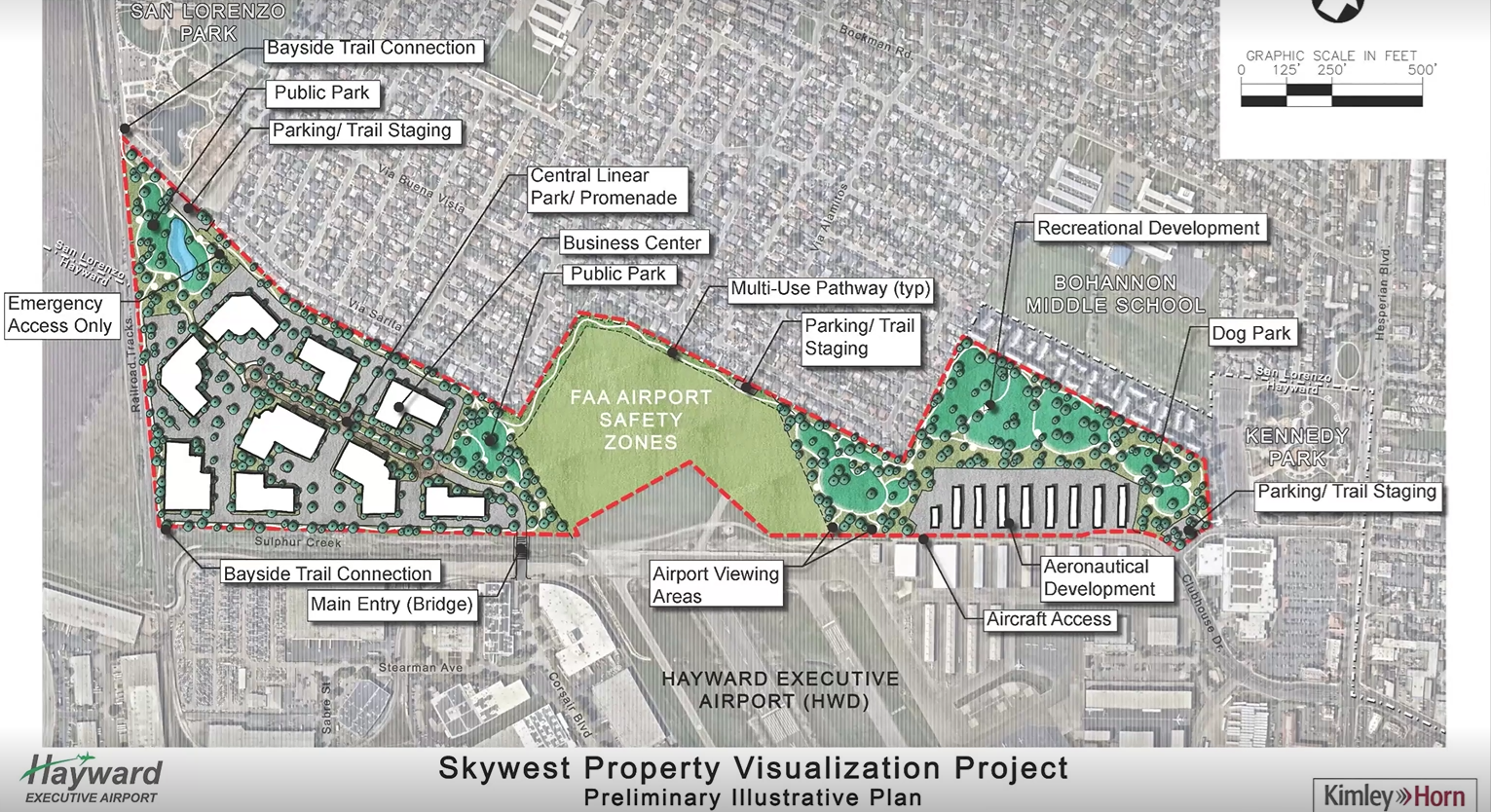
The image above is the last preliminary map of what the future development of the property could look like. It’s changed some, but it shows that the plan is to “provide something for everybody,” according to Airport Manager Doug McNeeley. The usable space—minus the Airport Safety Zones—are roughly divided into four uses: Business Development (41.8%), Open Space (39.8%). Aeronautical Development (11.2%), and Buffers (7.1%).
The amount of open space has increased since the last presentation, but still dedicates the majority of the space to Business Development purposes. Much of the presentation focused on the economic benefits of business development and the costs of operating a park space. According to Airport Manager McNeeley, the Airport generates approximately $4,400,000 in taxes for the City every year and could generate millions more with robust business development.
A number of restrictions on the site seem to limit what can be done with it. One of the primary issues is the apparent FAA regulation that requires the Airport rent land at market rate for non-aeronautical purposes—$1.18 per square foot.
This would mean that the 39 acres of open space proposed would cost almost $2,400,000 per year to rent from the airport. The annual maintenance, according to the Staff Report, would cost almost $4,000,000 per year—60% of which would be rent, with the next biggest cost being water at over $850,000 per year. They also estimated renovations to the space to cost over $53,000,000 for only 46 acres of land. Mr. McNeeley said that the estimates were based on the cost of La Vista Park.
The Cost Is Ludicrous
Some members of the public called out the cost and revenue estimates that were being used to justify the project. “The numbers [in the report] are ludicrous,” a public speaker said. They took issue with how the revenue possibility for the industrial park was calculated—used as an economic argument in favor of prioritizing its development—and how the cost of the park was calculated. “[HARD] runs several cities worth of parks for $44,000,000 per year,” they alleged.
For their part, representatives from HARD seemed to agree. HARD Director Louis Andrade was present at the meeting and said, “I think using La Vista Park as a model is way off.” He pointed out that members of the public are not looking for a manicured park like La Vista or even Kennedy Park but what he referred to as a “rustic park.” However, he stressed that he didn’t have all the details. “We haven’t been at the table as to how you arrived at the cost of development.”
And although Director Andrade expressed openness to partnerships, he was blunt about the proposed rent. “I don’t see, though, that we’re going to pay $1.18 per square foot as an annual lease for the parkland,” he said.
Community Still Favors Open Space
Over 15 people spoke in favor of keeping Skywest an open space, many highlighting the lack of other open spaces available to members of the community. “[I’m] someone who grew up having to drive 20 miles away just to access open space,” a commenter said.
Community organizer with SOS Skywest Mimi Dean pointed out that the numbers that had been put forward around park accessibility were misleading. She alleged that the park space was a citywide average and encouraged a report breaking it down by census tract, which gives a more granular picture of some places having access while others don’t—largely along class lines. “We might not have all the money that the people in the hills have,” she said, “but we deserve to have open space, too.”
Others argued that open space is a finite resource that rarely—if ever—comes back. “Open space is precious,” one commenter said. “Once it’s lost, it’s gone forever.” And the speakers were pretty adamant about keeping it wild. “I don’t think people that are supporting keeping it fully open have ever thought of it as being a manicured park,” one commenter said, “it’s gonna be more of a wild natural environment, supporting the habitat that already exists there.”
A Collaborative Tone
Multiple members of the committee praised the collaborative tone that was taken during the public comment period. “I felt like a lot of the comments were a lot more collaborative tonight,” Councilmember Andrews said. “And I think that is the key that we need to start talking about.” Mayor Salinas also praised the tone. “We are emphasizing collaboration,” he said.
And that collaborative spirit extended to local park district partners. Councilmember Andrews specifically asked for coordinated help from HARD. “I am concerned about the estimates we’re receiving,” she said, and expressed interest in the rustic park from a cost standpoint. She also asked for information about grants or partners who would be able to grant money to, “either preserve the space or look at how to have a more nature-based approach,” she said.
Councilmember Syrop pointed out that the City has no experience managing parks. He pressed for conversations with HARD and the East Bay Regional Park District (EBRPD). “The City is not prepared to manage 126 acres of open space,” he said. “That’s just not our specialty.” Mayor Salinas agreed, “The City of Hayward is not a park district,” he said.
Cost Is A Concern
Aside from the cost of development, the millions of dollars in annual rent that is being asked raised eyebrows from the Committee. Councilmember Syrop asked if the rent was in any way flexible, assuming so because of the prior agreement with HARD. “Tat cost, then, is pretty flexible because this feels like a really high estimate,” he said.
However, Mr. McNeeley pointed out that the former rate was part of a 20 year lease by HARD which did not build in any rent increases. According to him, the FAA requires a market rate of $0.35 per square foot for Aeronautical purposes and $1.18 per square foot for non-aeronautical purposes. “But we’re not talking about a private enterprise,” Councilmember Syrop said, “this is a public agency—” Mr. McNeeley interrupted, “They don’t make a distinction.”
More Outreach Coming
After the meeting, more outreach to the community is coming. The last round of community feedback—outside of a committee meeting—was in 2021 and the Committee encouraged the Airport administration to go out to the people.
Mayor Salinas asked for more feedback from people South of the airport, specifically south of A Street—many of the speakers live toward the North end of the Airport and in San Lorenzo. Councilmember Andrews asked them to work with HUSD to try to get more outreach at nearby school sites.
Planning For Safe Streets
The City is looking to improve safety on some high-injury corridors across town. Three of the biggest offenders are A Street, B Street, and Tennyson Road, which are a part of the City’s High Injury Network—a series of streets that make up only 14% of the City’s road miles but where 75% of all fatal accidents/serious injuries occur. After a lot of outreach, the committee was faced with a few options on what to do for each street.
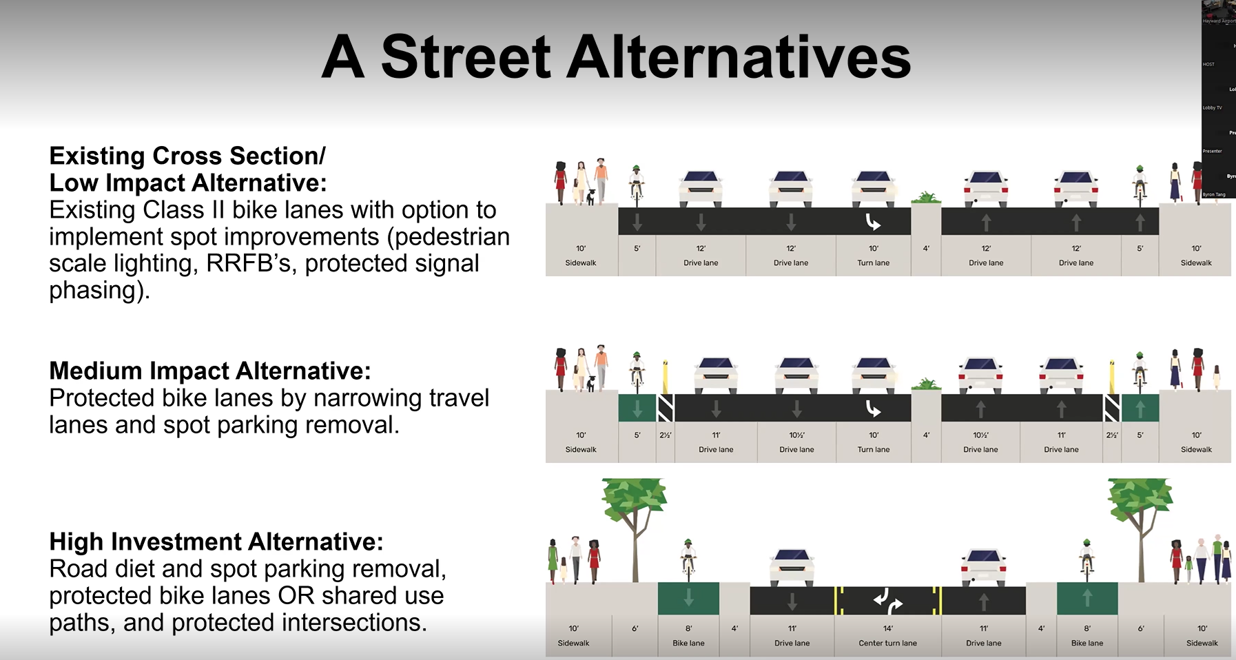
For A Street, the images above show what the different alternatives would look like. The High Investment Alternative would require a serious road diet—losing a full driving lane, which may or may not have a big impact on traffic—while also gaining street trees and fully separated bike lanes. On the other end of the spectrum, the Low-Investment Alternative leaves things more or less as they are now.
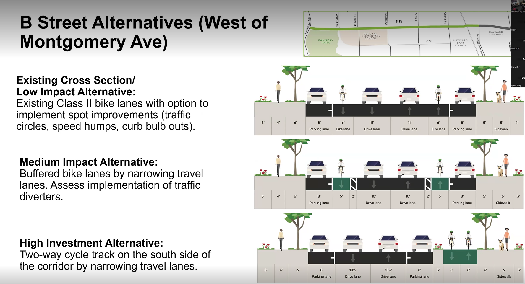
B Street is divided into two sections: West and East of Montgomery Ave—where the BART Station is. This section goes from the BART station to Cannery Park. The Medium Investment Alternative would essentially extend the conditions West of Grand all the way to the BART station. The High Investment Alternative would be a big change and make a two-way cycle track on one side of the street.
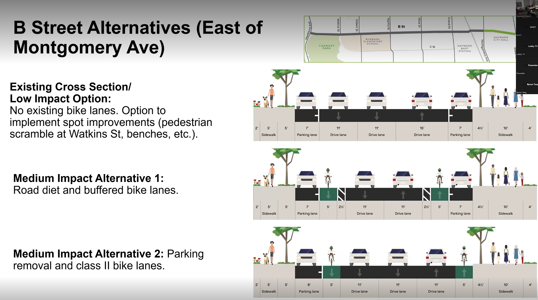
East of Montgomery—between the BART Station and City Hall—has two different Medium Investment Alternatives which show the need for trade-offs between driving lanes and parking lanes when adding bike lanes.
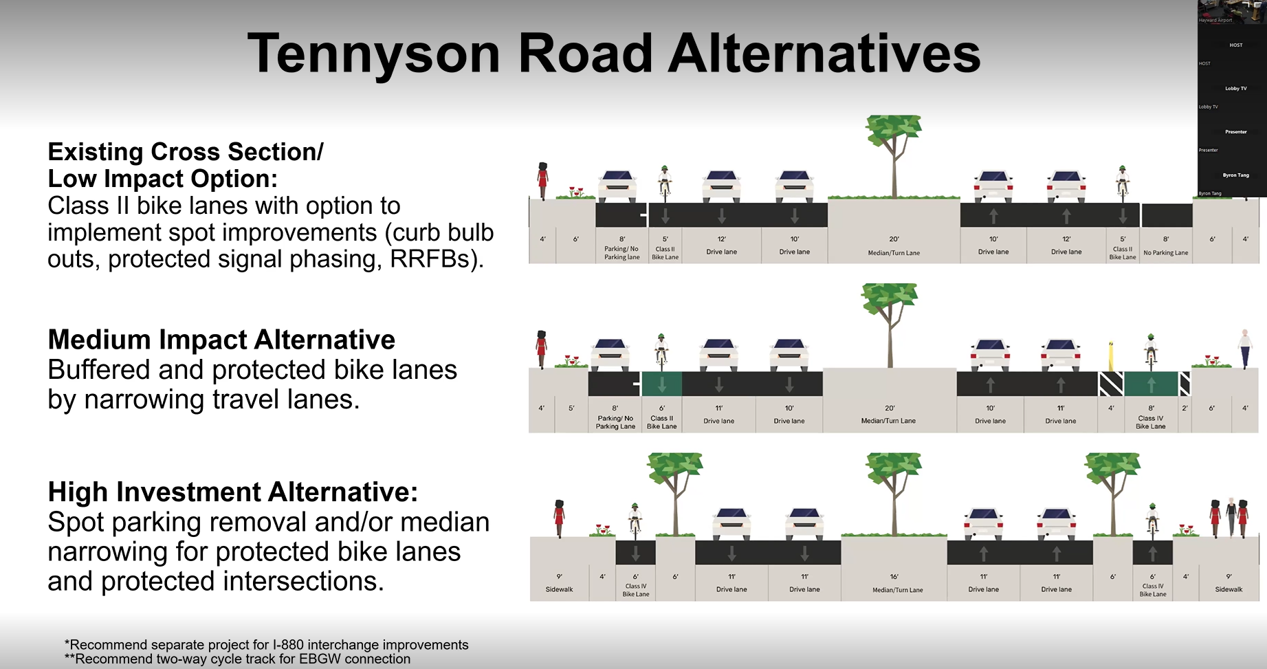
Tennyson Road’s alternatives look a little strange at first—especially with removing parking on only one side of this very wide road for the Medium Investment Alternative. Staff pointed out that the High Investment Alternative—which, as pictured would remove all street parking—could save the street parking by narrowing the median. The median is currently 20 feet across—the equivalent of two driving lanes.
Staff pointed out that this is just the first presentation of options and that further analysis would be done, along with at least two more community outreach efforts. Any final plan wouldn’t be approved until almost a year from now—Fall/Winter 2026.
Safety Is A Priority To Invest In
The safety of pedestrians and cyclists was at the top of mind for both commenters and the Councilmembers on the committee. Alejandro Jasso of Bike Hayward pointed out the limitations of flexible plastic post. “As we’ve seen on Orchard Avenue, those things get destroyed by drivers super-easily,” he said. He recommended concrete barriers or posts to really offer protection.
But that protection also required narrowing lanes and slowing traffic. Mr. Jasso also pointed out that without that, nothing else may matter. “Even the trees weren't enough to protect a pedestrian who was on the sidewalk who got killed,” he said.
A representative of Bike East Bay took issue with the language of on the slides, which refer to a low impact alternative. “I take issue with the term Low Impact option,” he said, “because people are definitely impacted by what’s there.”
Councilmember Syrop also pushed for more robust investments in safety infrastructure—specifically calling out the flexible posts. “If there’s infrastructure that we’re investing in,” he said, “let’s make it look like infrastructure.” He expressed a desire to move away from pilot projects. “We’ve been giving folks the suggestion to not run over bicyclists, now lets not let them run over bicyclists.”
Thanks for reading Hayward Herald! This post is public so feel free to share it.
With that in mind, he pushed to exclude any discussion of the low investment alternatives. “I don’t even want to talk about the low impact alternatives because they’re so similar to the existing conditions,” he said. He celebrated some of the corridor-wide improvements, like protected left turn phasing, curb bulb-outs, and high visibility crosswalks and pushed for them to be implemented sooner rather than later.
“The feedback we’re getting from the community is that they want better pedestrian and cyclist safety,” Councilmember Syrop said. Councilmember Andrews agreed. “I’m all about pedestrian improvements and bicycle improvements,” she said.” She placed special emphasis on the on/off ramps to 880 on Tennyson Road. “It’s an urgent need,” she said.
But Councilmember Andrews also addressed the community pushback against recent bicycle safety investments and called for Staff to do outreach in the affected communities. “That’s why we’re getting these angry emails,” she said, “because we’re making decisions at City Hall, Skywest, and they may not go to that Night Market.”
She suggested a phased approach to implementation. “So we can better explain to the community,” she said, we just want to see how the community adjusts to the change versus just automatically putting in the change.”
Mayor Salinas closed by agreeing that the medium or high investment ideas were the only ones worth considering because of safety concerns. “I think it’s undisputed that the position of the committee and Council has taken when it comes to protected bike lanes and investing in pedestrian safety,” he said. “At the end of the day, you look at those high injury networks, they are in these corridors where people just need to slow down. We’ll keep fighting for protected bike lanes.”
Comments ()